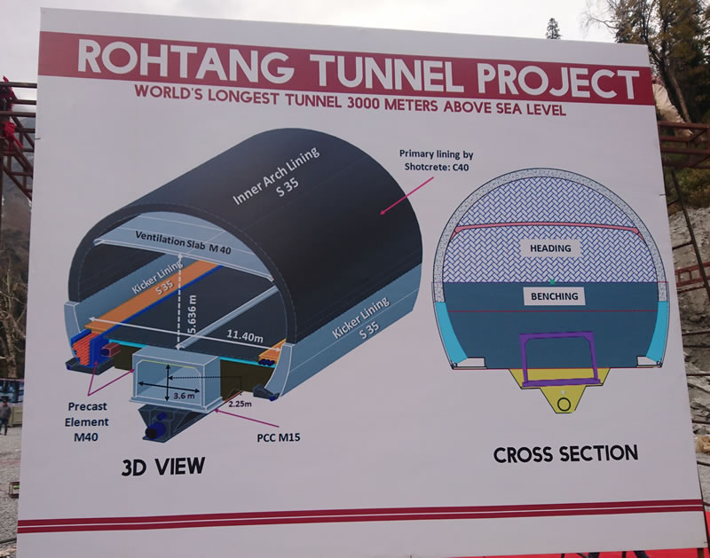
The feasibility study for the Rohtang Highway Tunnel Project started about 25 years before the award of Project to the STRABAG AG-AFCONS Joint Venture (SAJV). This project envisages building for the Government of India's Border Roads Organisation (the Client), a road tunnel of Horse shoe shape having 12.0 meters finished diameter and 8.85 kilometres length at the Rohtang Pass which is situated at a height of 3070 meters above mean sea level, in the Pir Panjal mountains of the Indian Himalayan Range. The tunnel will allow all weather two way movement for the Indian Army and also for the mostly tribal population living in the Lahaul Spiti district of the state of Himachal Pradesh in India, which otherwise remained snow bound during the winter months. Eventually, after the building of three more similar tunnels proposed along the same alignment, the entire Manali-Leh National Highway No 3 will become an all weather road.

The main contract between SAJV and the Client was signed on 22nd October 2009, and on 17th April 2010 SAJV awarded the entire survey contract for the project to Strabag India's Survey Division. After an initial delay caused by adverse climatic conditions, to make for lost time, in March 2010 three Survey teams headed by Strabag India's Chief Surveyor was mobilised in advance to the Manali site.
The Client's Engineer handed over to us, the list of available survey control points with its coordinates. We could recover all the listed control points but all weather access to all points was not possible, we established four Control points at South Portal area. Since we had to start the portal marking and site activity before the confirmation of relation between the coordinates of South Portal SP 1 and North Portal NP 2 it was agreed in a meeting with the Engineer’s Representative, that we assume the coordinates of South Portal as correct and start the site work at South Portal as per drawing.

Check Traverse Survey of Control point was started from South Portal to North Portal with the help of Leica TCA 1800 with light attachment and 3D traverse was completed in 15 days. And double run levelling Traverse from South Portal to North Portal was completed in 75 days with the help of Leica DNA 3/DNA 10. Doing levelling from Marhi to Koksar was very difficult due to unpredictable weather, strong wind and no shelter in 35 Kilometres of area. After processing all the raw data of the Total station and the Digital level we found the difference in the coordinates of North Portal 1.7 m in Easting, 3.7m in Northing and 1.57m in Elevation. Since the error in the data provided was huge, a GPS network measurement was also made and the post processing result was matching with that of the Total Station Network within 3-4 cms. The drawings were therefore corrected and the location of the North Portal was changed as required.

The accuracy of the tunnelling activity which was undertaken simultaneously from the North and South portals was continuously monitored by the Strabag India Survey Team using Leica TCRA 1201 plus and TCRA 1203 Plus with inbuilt profiling instruments. The software used were Eupalinos, NRG and Auto CAD Civil 3D software. To reconfirm the accuracy of the surveying, two Gyro measurement campaigns were conducted in August 2012 and October 2016 by using GYROMAT 3000 the patented DMT Technology from Germany.Thanks to the state of the art technology used, its proper implementation, the team spirit of those involved, and the active support of the International management team in the Indian survey activity, the breakthrough was achieved on 15th October 2017 with an accuracy of +/- 5 centimetres without any accident or loss of time attributable to Strabag India's Survey team.
The precision of the highest order achieved in this breakthrough is yet another testimony of the STRABAG Group's worldwide ability to successfully deliver projects of the best standards to its clients.
Harendra Prasad
Director - Survey Division, STRABAG India Pvt. Ltd.
|